Southeast
The Southeast and Caribbean region is exceptionally vulnerable to sea level rise, extreme heat events, hurricanes, and decreased water availability. The geographic distribution of these impacts and vulnerabilities is uneven, since the region encompasses a wide range of environments, from the Appalachian Mountains to the coastal plains. The region is home to more than 80 million people and some of the fastest-growing metropolitan areas, three of which are along the coast and vulnerable to sea level rise and storm surge. The Gulf and Atlantic coasts are major producers of seafood and home to seven major ports that are also vulnerable. The Southeast is a major energy producer of coal, crude oil, and natural gas, and is the highest energy user of any of the National Climate Assessment regions.
The Southeast warmed during the early part of last century, cooled for a few decades, and is now warming again. Temperatures across the region are expected to increase in the future. Major consequences include significant increases in the number of hot days (95°F or above) and decreases in freezing events. Higher temperatures contribute to the formation of harmful air pollutants and allergens. Higher temperatures are also projected to reduce livestock and crop productivity., Climate change is expected to increase harmful blooms of algae and several disease-causing agents in inland and coastal waters.,,,, The number of Category 4 and 5 hurricanes in the North Atlantic and the amount of rain falling in very heavy precipitation events have increased over recent decades, and further increases are projected.
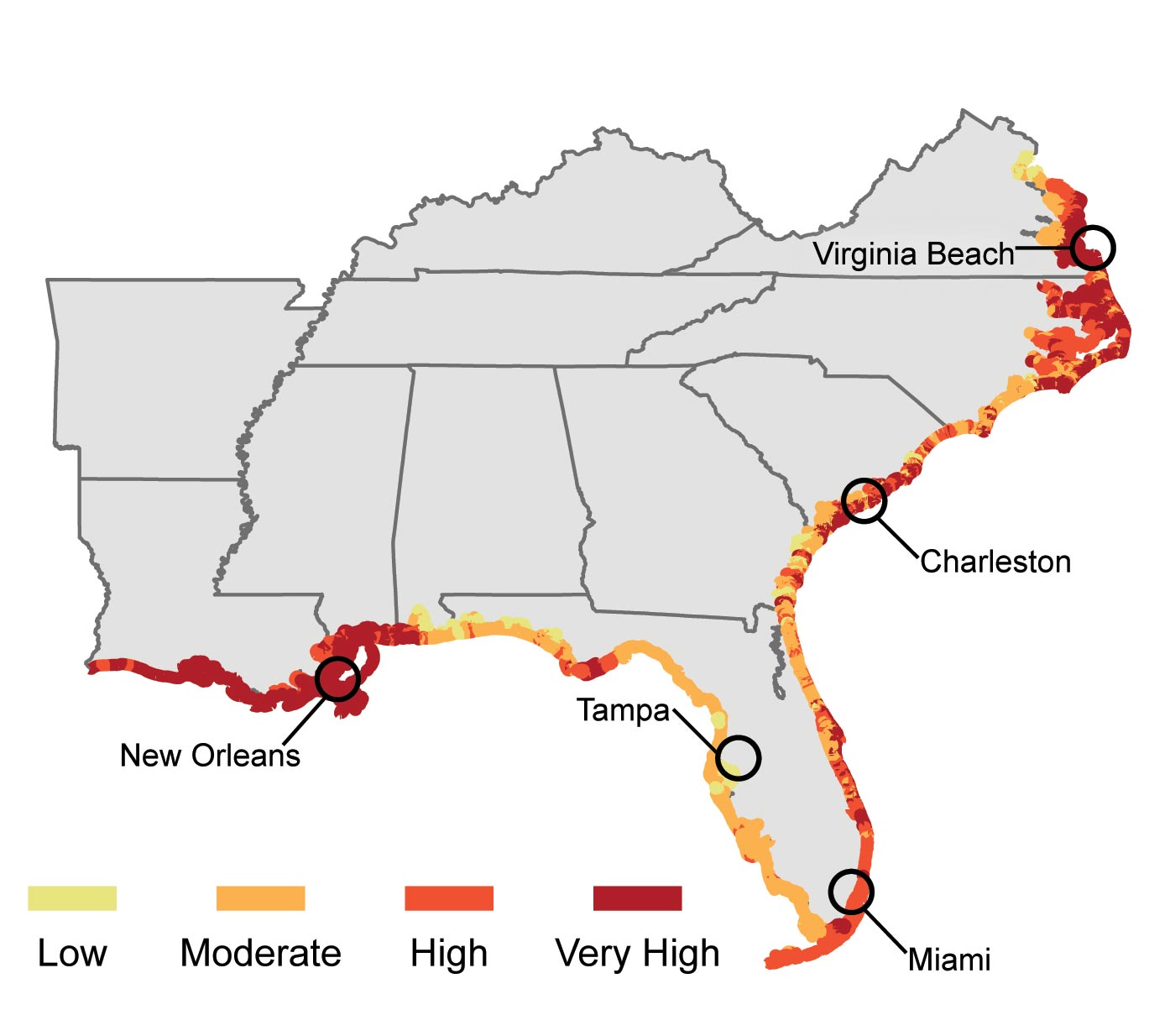
Global sea level rose about eight inches in the last century and is projected to rise another 1 to 4 feet in this century. Large numbers of southeastern cities, roads, railways, ports, airports, oil and gas facilities, and water supplies are vulnerable to the impacts of sea level rise. Major cities like New Orleans, with roughly half of its population below sea level, Miami, Tampa, Charleston, and Virginia Beach are among those most at risk.
As a result of current sea level rise, the coastline of Puerto Rico around Rincòn is being eroded at a rate of 3.3 feet per year. Puerto Rico has one of the highest population densities in the world, with 56% of the population living in coastal municipalities.
Sea level rise and storm surge can have impacts far beyond the area directly affected. Sea level rise combines with other climate-related impacts and existing pressures such as land subsidence, causing significant economic and ecological implications. According to a recent study co-sponsored by a regional utility, coastal areas in Alabama, Mississippi, Louisiana, and Texas already face losses that annually average $14 billion from hurricane winds, land subsidence, and sea level rise. Losses for the 2030 timeframe could reach $23 billion assuming a nearly 3% increase in hurricane wind speed and just under 6 inches of sea level rise. About 50% of the increase in losses is related to climate change.
Louisiana State Highway 1, heavily used for delivering critical oil and gas resources from Port Fourchon, is sinking, at the same time sea level is rising, resulting in more frequent and more severe flooding during high tides and storms. A 90-day shutdown of this road would cost the nation an estimated $7.8 billion.
Freshwater supplies from rivers, streams, and groundwater sources near the coast are at risk from accelerated saltwater intrusion due to higher sea levels. Porous aquifers in some areas make them particularly vulnerable to saltwater intrusion., For example, officials in the city of Hallandale Beach, Florida, have already abandoned six of their eight drinking water wells.
Continued urban development and increases in irrigated agriculture will increase water demand while higher temperatures will increase evaporative losses. All of these factors will combine to reduce the availability of water in the Southeast. Severe water stress is projected for many small Caribbean islands.
Selected Adaptation Efforts
 ©CCWA
©CCWAClayton County, Georgia’s innovative water recycling project enabled it to maintain abundant water supplies, with reservoirs at or near capacity, during the 2007-2008 drought, while neighboring Lake Lanier, the water supply for Atlanta, was at record lows. The project involved a series of constructed wetlands (see photo) used as the final stage of a wastewater treatment process that recharges groundwater and supplies surface reservoirs. The county has also implemented water efficiency and leak detection programs.
In other adaptation efforts, the North Carolina Department of Transportation is raising U.S. Highway 64 across the Albemarle-Pamlico Peninsula by four feet, which includes 18 inches to allow for higher future sea levels.,,
For another example, see Adaptation for a description of the Southeast Florida Regional Compact’s plans to reduce heat-trapping gas emissions and adapt to climate change impacts.