
Cloud-Aerosol Transport System (CATS) - 01.30.19
The Cloud-Aerosol Transport System (CATS) investigation uses a light detection and ranging (LiDAR) system to measure the location, composition and distribution of pollution, dust, smoke, aerosols and other particulates in the atmosphere. CATS is mounted on the Japanese Experiment Module's Exposed Facility and is used to study the atmospheric constituents that impact global climate. By gaining a better understanding of cloud and aerosol coverage, scientists can create a better model of the Earth's climate feedback processes. Science Results for Everyone
Information Pending
OpNom: CATS
Principal Investigator(s)
Matthew J. McGill, Goddard Space Flight Center, Greenbelt, MD, United States
Co-Investigator(s)/Collaborator(s)
John E. Yorks, M.S., Goddard Space Flight Center, Greenbelt, MD, United States
Developer(s)
NASA Goddard Space Flight Center, Greenbelt, MD, United States
Sponsoring Space Agency
National Aeronautics and Space Administration (NASA)
Sponsoring Organization
NASA - Science Mission Directorate (NASA-SMD)
Research Benefits
Earth Benefits
ISS Expedition Duration
September 2014 - March 2016; March 2016 - October 2018; March 2019 - October 2019
Expeditions Assigned
41/42,43/44,45/46,47/48,49/50,51/52,53/54,55/56,59/60
Previous Missions
Information Pending
Experiment Description
Research Overview
- The Cloud-Aerosol Transport System (CATS) investigation uses a remote sensing instrument designed to provide measurements of atmospheric clouds and aerosols. The impact of clouds and aerosols (e.g., pollution, dust, smoke) on a global scale with regards to energy balance and climate feedback mechanisms is not yet fully understood.
- A better understanding of cloud and aerosol coverage and properties is critical for understanding of the Earth system and its associated climate feedback processes. The CATS LiDAR obtains range-resolved information which can be used to assess the climate impacts of clouds and aerosols on a global scale.
- The orbit of the International Space Station (ISS) is particularly suited to measurements of this kind, because the ISS passes over and along many of the primary aerosol transport paths within the atmosphere. The ISS orbit also permits study of diurnal (day to night) changes due to the effects of aerosols and clouds in the atmosphere – something other Earth Science satellites cannot readily obtain given their orbits.
Description
Applications
Space Applications
An improved understanding of the makeup, structure and evolution of Earth's atmosphere can enhance spacecraft launch, landing and communications. It can also help guide future experiments investigating different atmospheres such as Mars, Jupiter, and other worlds.
Earth Applications
CATS provides continuity for the Cloud-Aerosol Lidar and Infrared Pathfinder Satellite Observations (CALIPSO) that previously launched and now is in its extended phase. Long-term observations of Earth’s atmosphere are needed to help researchers model and predict climate changes.
Operations
Operational Requirements and Protocols
Decadal Survey Recommendations
Information Pending
^ back to topResults/More Information
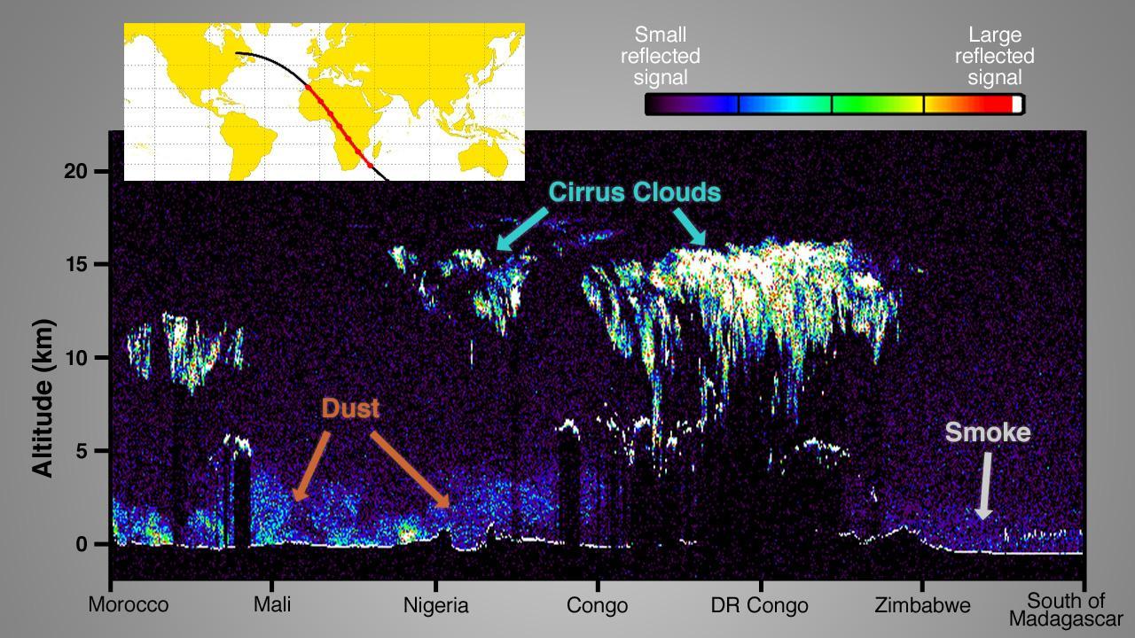
The Cloud-Aerosol Transport System (CATS) investigation uses a light detection and ranging (LiDAR) system to measure the location, composition, and distribution of pollution, dust, smoke, aerosols, and other particulates in the atmosphere. CATS results have provided direct evidence that space-based LiDAR layer detection at 1064 nm is more representative of the true above-cloud aerosols scene compared to 532 nm. More accurate measurement of the vertical distribution of aerosols in the future will improve understanding of the semidirect effects of smoke plumes from biomass burning in Africa across the SE Atlantic. By gaining a better understanding of cloud and aerosol coverage, scientists can create a better model of the Earth’s climate feedback processes.
^ back to topResults Publications
McGill MJ, Yorks JE, Scott S, Kupchock AW, Selmer PA. The Cloud-Aerosol Transport System (CATS): a technology demonstration on the International Space Station . Proceedings of SPIE 9612, Lidar Remote Sensing for Environmental Monitoring XV, San Diego, CA; 2015 September 1
Hughes EJ, Yorks JE, Krotkov NA, da Silva AM, McGill MJ. Using CATS near-real-time lidar observations to monitor and constrain volcanic sulfur dioxide (SO2) forecasts. Geophysical Research Letters. 2016 October 28; 43(20): 11,089-11,097. DOI: 10.1002/2016GL070119.
Chuang T, Burns P, Walters EB. Space-based, multi-wavelength solid-state lasers for NASA's Cloud Aerosol Transport System for International Space Station (CATS-ISS). Proceedings of SPIE 8599, Solid State Lasers XXII: Technology and Devices, San Francisco, CA; 2013 March 6
Yorks JE, McGill MJ, Palm SP, Hlavka DL, Selmer PA, Nowottnick EP, Vaughan MA, Rodier SD, Hart WD. An overview of the CATS level 1 processing algorithms and data products. Geophysical Research Letters. 2016 May 7; 43: 4632-4639. DOI: 10.1002/2016GL068006..
Rajapakshe C, Zhang Z, Yorks JE, Yu H, Tan Q, Meyer K, Platnick S, Winker DM. Seasonally transported aerosol layers over southeast Atlantic are closer to underlying clouds than previously reported. Geophysical Research Letters. 2017 June 16; 44(11): 5818-5825. DOI: 10.1002/2017GL073559.
Noel V, Chepfer H, Chiriaco M, Yorks JE. The diurnal cycle of cloud profiles over land and ocean between 51° S and 51° N, seen by the CATS spaceborne lidar from the International Space Station. Atmospheric Chemistry and Physics. 2018 July 6; 18(13): 9457-9473. DOI: 10.5194/acp-18-9457-2018.
Ground Based Results Publications
ISS Patents
Related Publications
McGill MJ, Hlavka DL, Hart WD, Scott VS, Spinhirne , Schmid . Cloud Physics Lidar: instrument description and initial measurement results. Applied Optics. 2002 Jun 20; 41(18): 3725-3734. DOI: 10.1364/AO.41.003725.
McGill MJ, Rallison RD. Holographic optics convert rings to points for detection. Laser Focus World. 2001; 37(3): 131-136.
McGill MJ, Hlavka DL, Hart WD, Welton E, Campbell JR. Airborne lidar measurements of aerosol optical properties during SAFARI-2000. Journal of Geophysical Research. 2003 July; 108(D13): 16. DOI: 10.1029/2002JD002370.
McGill MJ, Hlavka DL, Vaughan MA, Trepte CR, Hart WD, Winker DM, Keuhn R. Airborne validation of spatial properties measured by the CALIPSO lidar. Journal of Geophysical Research. 2007 October 17; 112(D20): 27. DOI: 10.1029/2007JD008768.
Related Websites
Cloud-Aerosol Transport System (CATS) website
Earth Right Now
Imagery
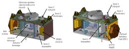
 Schematic showing a primary component breakout of the of the CATS investigation. This investigation supports a standard JEM-EF attached payload volume.
+ View Larger Image

+ View Larger Image

+ View Larger Image

+ View Larger Image
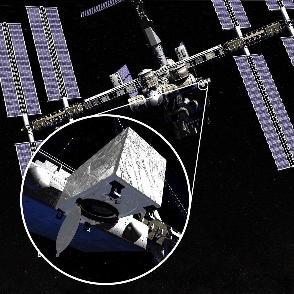
 Artistic representation of the Cloud-Aerosol Transport System (CATS). CATS will measure clouds and aerosols in the Earth's atmosphere. It will be mounted externally on the International Space Station.
+ View Larger Image

+ View Larger Image

+ View Larger Image
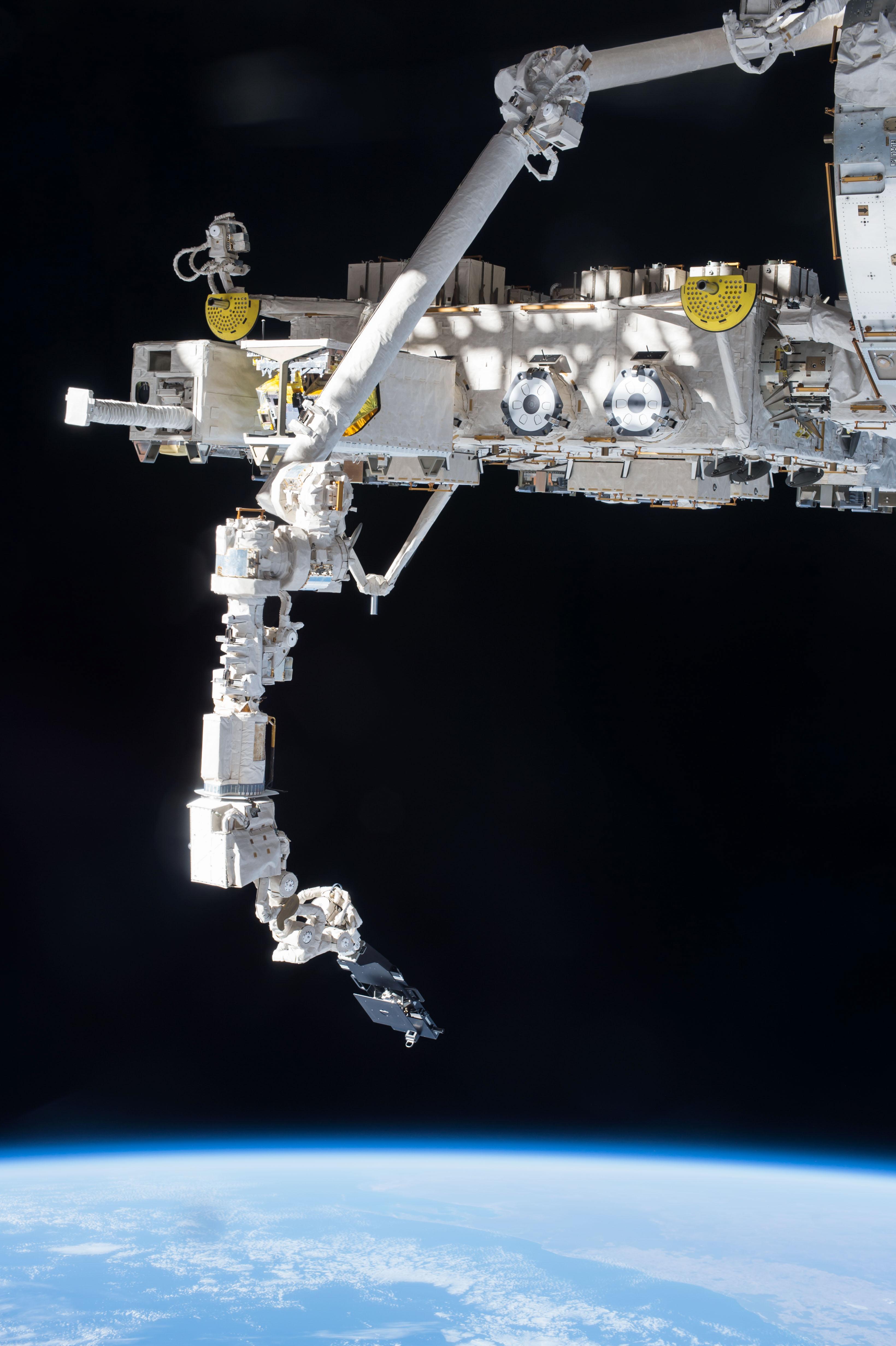
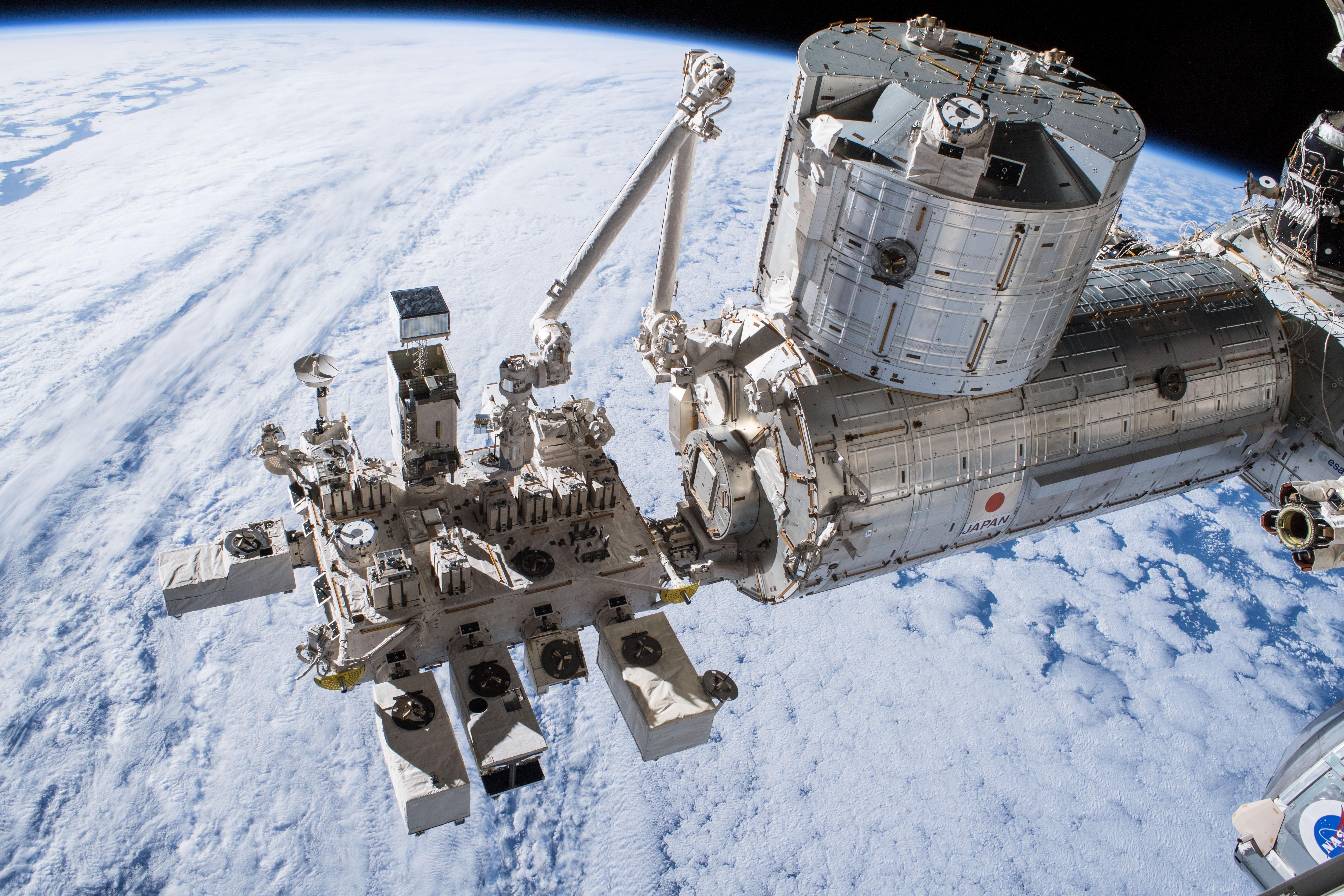
 NASA Image: ISS050E011669 - Japanese Experiment Module (JEM) Pressurized Module (JPM) and Japanese Experiment Module - Exposed Facility (JEM-EF) with the darkness of Earth in the background taken by Expedition 50.
 + View Larger Image

+ View Larger Image